


10 Acres Unspoiled Desert Land at Base of the Tehachapi Mountains
10 acres zoned A (Agriculture, allows single family residence as well) in the area north of Neenach and west of Willow Springs, CA 93560. Located at the base of the Tehachapi Mountains, directly adjacent to the historic Rancho La Liebre, now part of Tejon Ranch. Panoramic views of beautiful desert and mountains in all directions. The land is approximately flat. Dirt roads behind locked gates reach the property. This is the far southern portion of Kern County, a few miles north of the Los Angeles County line. This is a mostly undeveloped area currently, with only one neighbor (about a mile away) visible in any direction from the property. Given the torrid growth of both Los Angeles County and Kern County, including growing demand for land for agriculture and solar projects among other things, chances are demand for this land will increase significantly over time. It might make a wonderful, tranquil, remote, beautiful homesite or hobby farm today.
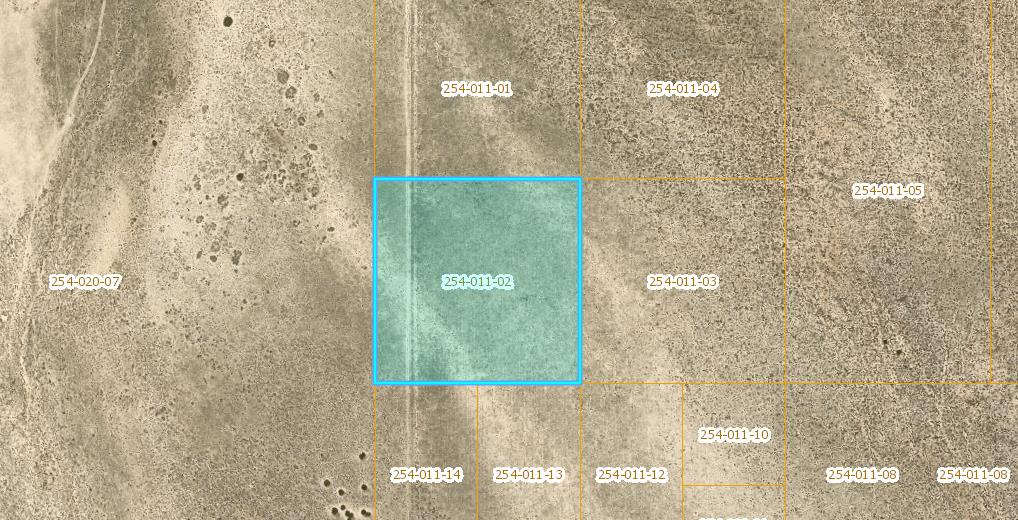
APN 254-011-02-00-7
Directions: It’s a bit tricky to reach the property your first time, particularly if you aren’t familiar with the area. There are various possible routes, here is one: Take Hwy 138/W Ave D to 230th St W. Reset your odometer, go north on 230th St W for 5.2 miles, then turn left on the paved Los Angeles Aqueduct road. Follow this road west for 1.15 mi, then turn righ off of the paved road, heading west on Holiday Ave. Go west on Holiday Ave 0.5 miles, then turn right on 245th St W, arriving at a locked gate. You will not be able to get through this gate–call listing broker some days in advance of your visit to make arrangements for access. Once you do obtain access from listing broker to continue past the gate, and preferably are driving a 4WD/AWD vehicle, proceed north past the gate 2.0 miles on 245th St E, at which point you will reach another gate. You will not go through this gate, but instead turn left onto a faint dirt trail road (the roads are mostly faint from this point on, so carefully follow these directions in order to easily arrive at the property). Follow the faint dirt trail road west 0.4 miles, at which point it turns right (north) for 0.1 miles, then continues northwest 0.4 miles, then north 0.2 miles, arriving at the Tejon Ranch boundary’s barbed wire fence. Turn right (east) along the fenceline, proceed 200 feet, then turn left to continue following the fenceline north. Proceed north approximately 800 feet, at which point you will be at the southwest property corner. From this point the property continues 660 feet to the north and 660 feet to the east.
GPS 34.887676, -118.571326
What3Words ///transistor.disagreement.reactors