


5.18 ACRES LAND IN TWO PARCELS, VIRTUALLY SURROUNDED BY CITY
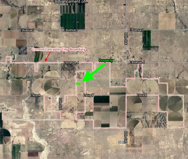
Two parcels of 2.59+- acres each, totaling 5.18+- acres, zoned A-2 (Heavy Agriculture, allows single family residence as well) in Roosevelt (Lancaster), CA 93535. The City vitually surrounds this parcel, encroaching on it from the north, east, and west sides, and in fact directly adjacent to its west boundary. This appears to be an excellent buy and hold land-bank investment as Lancaster continues to grow, for the City will almost certainly want to annex this property in the future. When will a developer come calling, wishing to purchase this property at a high price or joint venture it into a significant project? One day, almost certainly.
This property is located at approximately Avenue J10 and 75th/76th Street East in the neighborhood of Roosevelt, which is a neighborhood within the larger Lancaster market. There are scattered homes, farms, businesses, an elementary school, and more in the vicinity. The land is flat desert topography, with views of the desert and distant mountain ranges. From satellite photos it appears these and neighboring parcels have been farmed at some point in the past, potentially indicating good groundwater. This property is inside of the City of Lancaster’s Sphere of Influence, which is the area the City is planned to grow into in the future.
Electricity lines are present 0.6 miles to the south along Avenue K. Well and septic are the typical water and waste disposal types in this market area at present should you be purchasing with the intent to build.
This property is located just 0.6 miles north of Avenue K (paved, with electricity), fronting 75th Street East.
Los Angeles County APN’s 3384-011-013 and 3384-011-016
Directions: From Lancaster, take Avenue K east to the intersection of 75th Street East, and turn left. Proceed 0.6 miles north. At this point, the property will be on your right (east). The approximate corners of each parcel are marked.
GPS 34.680455, -117.995231 (on the approximate boundary between the two parcels)
What3Words fronting.device.soft